Windows Support Number

  • Subscribe to our RSS feed.
  • Twitter
  • StumbleUpon
  • Reddit
  • Facebook
  • Digg

Friday, 28 October 2011

Tessellating shapes on top of Bing Maps in a WP7 app

Posted on 09:37 by Unknown
Before I complete the 'How many pins can Bing Maps handle in a WP7 app...' set of posts. I want to take one last diversion and show how you can tessellate shapes on top of the Bing Maps control in a WP7 app. This builds on top of a previous post about drawing shapes on top of Bing Maps. If you're unsure what tessellation is, then the following definition should give you a good idea:

A tessellation is created when a shape is repeated over and over again covering a plane without any gaps or overlaps.

Only three regular polygons tessellate in the Euclidean plane: triangles, squares or hexagons. Shown below are some graphical examples of how these shapes tessellate:

I'm only going to show how you can tessellate these shapes on top of the map control. The effect will be rendered as a set of MapPolygon class instances. You could achieve a similar effect with a set of MapPolyline class instances and it would be probably a lot easier but, and it is an important 'but', if you use a MapPolyline you won't be able to use the polygon colour fill functionality. The MapPolygon instances are render as a layer on top of the map control, the control provides this functionality out of the box, this means the XAML is very clean and easy to understand:


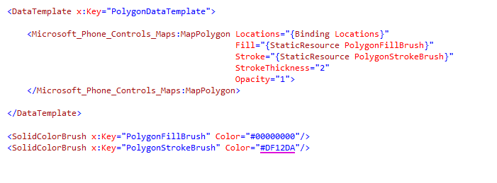
As you can see the polygons are rendered as part of the MapItemsControl instance, the item source is bound to the Polygons property on the ViewModel. The item template is shown below and you can see this is also very simple. I've also included the brush definitions so you can see where the polygon colours are defined:

Before I dive into the code used to generate the polygons lets see the effect I'm going to generate, shown below are a set of tessellated shapes at different sizes. The density of polygons on the screen is dependent on the zoom level of the map control - here I'm using a default zoom level of 13 when the app starts, obviously you can zoom in and out as required and the polygons will automatically re size. This functionality is provided by the parent MapLayer class instance.


Here I'm using a set of pre-defined shapes, these are defined in the ViewModel constructor which is shown below. You can see each Shape class instance has a Name property and 2 function delegate properties - PolygonFunc and AdjacentPolygonFunc. This is the same style I used in the previous post.

public MapViewModel(ILog log)
{
this.log = log;

this.polygons = new ObservableCollection<Polygon>();
this.datum = new GeoCoordinate(51.54590803376571, -0.10334014892578125);
this.Centre = new GeoCoordinate(51.561811605968394, -0.0883626937866211);

this.Zoom = 13;

this.shapes = new ObservableCollection<Shape>
{
new Shape { Name = "No Shape", PolygonFunc = centre => new Polygon(), AdjacentPolygonFunc = centre => new List<Polygon>() },
new Shape { Name = "Square (100 m)", PolygonFunc = MapFuncs.Square(100), AdjacentPolygonFunc = MapFuncs.AdjacentSquares(100) },
new Shape { Name = "Square (200 m)", PolygonFunc = MapFuncs.Square(200), AdjacentPolygonFunc = MapFuncs.AdjacentSquares(200) },
new Shape { Name = "Square (500 m)", PolygonFunc = MapFuncs.Square(500), AdjacentPolygonFunc = MapFuncs.AdjacentSquares(500) },
new Shape { Name = "Square (1 km)", PolygonFunc = MapFuncs.Square(1000), AdjacentPolygonFunc = MapFuncs.AdjacentSquares(1000) },
new Shape { Name = "Square (1 mile)", PolygonFunc = MapFuncs.Square(1609.347), AdjacentPolygonFunc = MapFuncs.AdjacentSquares(1609.347) },
new Shape { Name = "Triangle (3 sides, 500 m)", PolygonFunc = MapFuncs.Triangle(500), AdjacentPolygonFunc = MapFuncs.AdjacentTriangles(500) },
new Shape { Name = "Triangle (3 sides, 1 km)", PolygonFunc = MapFuncs.Triangle(1000), AdjacentPolygonFunc = MapFuncs.AdjacentTriangles(1000) },
new Shape { Name = "Triangle (3 sides, 1 mile)", PolygonFunc = MapFuncs.Triangle(1609.347), AdjacentPolygonFunc = MapFuncs.AdjacentTriangles(1609.347) },
new Shape { Name = "Hexagon (6 sides, 500 m)", PolygonFunc = MapFuncs.Hexagon(500), AdjacentPolygonFunc = MapFuncs.AdjacentHexagons(500) },
new Shape { Name = "Hexagon (6 sides, 1 km)", PolygonFunc = MapFuncs.Hexagon(1000), AdjacentPolygonFunc = MapFuncs.AdjacentHexagons(1000) },
new Shape { Name = "Hexagon (6 sides, 1 mile)", PolygonFunc = MapFuncs.Hexagon(1609.347), AdjacentPolygonFunc = MapFuncs.AdjacentHexagons(1609.347) },
};
this.SelectedShape = this.shapes[5];
}

Hopefully the delegate method names are obvious, PolygonFunc calculates the geo-location points for the shape and the AdjacentPolygonFunc. The shapes are divided into 2 distinct groupings - squares and everything else. Squares are easy to calculate because you only have to calculate geo-locations for 4 points using constant bearings  - 0, 90, 180 & 270. Everything else is where it starts to get complicated, you have to use a circle and calculate the position of each point on the circumference. The diameter for the circle comes from the defined size of the shape.

Shown below is the PolygonFunc method for creating a hexagon, as you can see the hexagon is generated using the Polygon method we also set the Height & Width of the generated polygon.

public static Func<GeoCoordinate, Polygon> Hexagon(double diameter)
{
Func<GeoCoordinate, Polygon> func = location =>
{
var hexagon = Polygon(location, 6, diameter, 0, 0, 0);

var north = hexagon.Locations[0];
var south = hexagon.Locations[3];
var east = hexagon.Locations[1];
var west = hexagon.Locations[5];

hexagon.Height = north.GetDistanceTo(south);
hexagon.Width = east.GetDistanceTo(west);

return hexagon;
};

return func;
}

The Polygon method is shown below, this is ultimately the same method used to create triangles as well as hexagons:

private static Polygon Polygon(GeoCoordinate location, int sides, double diameter, double offset, double offsetBearing, double startAngle)
{
var centre = location;
if (offset != 0)
{
centre = CalculateUsingHaversine(centre, offset, offsetBearing);
}

var polygon = new Polygon();

var radius = diameter / 2;
var angle = CircleInDegresses / sides;

for (var i = 0; i < sides; i++)
{
var aggregatedAngle = (i * angle) + startAngle;
polygon.Locations.Add(CalculateUsingHaversine(centre, radius, aggregatedAngle));
polygon.Centre = centre;
polygon.TileBoundingRectangle = Square(diameter)(centre).TileBoundingRectangle;
}

return polygon;
}

For this demo I'm using the Haversine method for calculating distance between two geo-locations. There are more accurate ways to calculate geo-locations, I'm aware of the error factor (0.3 %) and happy to negate this for Haversine formula. The reason is simple - in a real-world app I won't be displaying a large number of polygons over a large areas (see the 'square 100 metre' in the above screenshot) so therefore the total distances calculated would not be large and the error factor would be small. Shown below is a screenshot of a single hexagon polygon rendered onto the map control.


The purpose of the AdjacentPolygonFunc method should be obvious - to calculate the adjacent polygons for an existing polygon. The implementation of this function depends on the type of polygon, the number of adjacent polygons for a square is different to a triangle or hexagon. Shown below are the rendered adjacents; I've added the order in which the adjacent polygons are calculated. An understand of the order of calculation is important when it comes to rendering the rest of the polygons for the visible map control.


As I said the adjacent methods are dependent on the type of polygon and calculating the adjacents for a square is the easiest. Shown below is the method used for adjacent hexagons. It requires not only the ability to calculate the polygon points but the ability to calculate the points in the correct geo-locations - the points have to be 'massaged' into the correction geo-locations.

public static Func<Polygon, List<Polygon>> AdjacentHexagons(double length)
{
Func<Polygon, List<Polygon>> func = hexagon =>
{
var adjacentPolygons = new List<Polygon>();
GeoCoordinate deltaNorthWest;
GeoCoordinate deltaNorthEast;
GeoCoordinate deltaSouthWest;
GeoCoordinate deltaSouthEast;

// Calculate the horizontal distance between the edge of the hexagon and the edge of the bounding rectangle
var eastEdge = new GeoCoordinate(hexagon.Locations.OrderByDescending(l => l.Latitude).Select(l => l.Latitude).First(),
hexagon.Locations.OrderByDescending(l => l.Longitude).Select(l => l.Longitude).First());

var horizontalDelta = eastEdge.GetDistanceTo(hexagon.TileBoundingRectangle.Northeast) * 2;

// Calculate the vertical distance between the top of the hexagon and the top of the east edge
var northEdge1 = hexagon.Locations.OrderByDescending(l => l.Latitude).First();
var northEdge2 = hexagon.Locations.OrderByDescending(l => l.Longitude).ThenByDescending(l => l.Latitude).First();

var verticalDelta = Math.Cos(DegreeToRadian(60.00)) * northEdge1.GetDistanceTo(northEdge2);

// Calculate top centre hexagon position....
deltaNorthWest = CalculateUsingHaversine(hexagon.TileBoundingRectangle.Northwest, verticalDelta, 180);
deltaNorthEast = CalculateUsingHaversine(hexagon.TileBoundingRectangle.Northeast, verticalDelta, 180);

var topCentre = AdjacentSquare(deltaNorthWest, deltaNorthEast, 0, 0, length);
topCentre.Locations = Hexagon(length)(topCentre.Centre).Locations;

// Calculate bottom centre hexagon position....
deltaSouthWest = CalculateUsingHaversine(hexagon.TileBoundingRectangle.Southwest, verticalDelta, 0);
deltaSouthEast = CalculateUsingHaversine(hexagon.TileBoundingRectangle.Southeast, verticalDelta, 0);

var bottomCentre = AdjacentSquare(deltaSouthWest, deltaSouthEast, 180, 180, length);
bottomCentre.Locations = Hexagon(length)(bottomCentre.Centre).Locations;

// Calculate centre right hexagon position...
deltaNorthEast = CalculateUsingHaversine(hexagon.TileBoundingRectangle.Northeast, horizontalDelta, 270);
deltaSouthEast = CalculateUsingHaversine(hexagon.TileBoundingRectangle.Southeast, horizontalDelta, 270);

var centreRight = AdjacentSquare(deltaNorthEast, deltaSouthEast, 90, 90, length);
centreRight.Locations = Hexagon(length)(centreRight.Centre).Locations;

// Calculate centre left hexagon position...
deltaNorthWest = CalculateUsingHaversine(hexagon.TileBoundingRectangle.Northwest, horizontalDelta, 90);
deltaSouthWest = CalculateUsingHaversine(hexagon.TileBoundingRectangle.Southwest, horizontalDelta, 90);

var centreLeft = AdjacentSquare(deltaNorthWest, deltaSouthWest, 270, 270, length);
centreLeft.Locations = Hexagon(length)(centreLeft.Centre).Locations;

// Calculate top right hexagon position...
deltaNorthEast = CalculateUsingHaversine(topCentre.TileBoundingRectangle.Northeast, horizontalDelta * 4.225, 270);
deltaSouthEast = CalculateUsingHaversine(topCentre.TileBoundingRectangle.Southeast, horizontalDelta * 4.225, 270);

var topRight = AdjacentSquare(deltaNorthEast, deltaSouthEast, 90, 90, length);
topRight.Locations = Hexagon(length)(topRight.Centre).Locations;

// Calculate top left hexagon position...
deltaNorthWest = CalculateUsingHaversine(topCentre.TileBoundingRectangle.Northwest, horizontalDelta * 4.225, 90);
deltaSouthWest = CalculateUsingHaversine(topCentre.TileBoundingRectangle.Southwest, horizontalDelta * 4.225, 90);

var topLeft = AdjacentSquare(deltaNorthWest, deltaSouthWest, 270, 270, length);
topLeft.Locations = Hexagon(length)(topLeft.Centre).Locations;

// Calculate bottom right hexagon position...
deltaNorthEast = CalculateUsingHaversine(bottomCentre.TileBoundingRectangle.Northeast, horizontalDelta * 4.225, 270);
deltaSouthEast = CalculateUsingHaversine(bottomCentre.TileBoundingRectangle.Southeast, horizontalDelta * 4.225, 270);

var bottomRight = AdjacentSquare(deltaNorthEast, deltaSouthEast, 90, 90, length);
bottomRight.Locations = Hexagon(length)(bottomRight.Centre).Locations;

// Calculate bottom left hexagon position...
deltaNorthWest = CalculateUsingHaversine(bottomCentre.TileBoundingRectangle.Northwest, horizontalDelta * 4.225, 90);
deltaSouthWest = CalculateUsingHaversine(bottomCentre.TileBoundingRectangle.Southwest, horizontalDelta * 4.225, 90);

var bottomLeft = AdjacentSquare(deltaNorthWest, deltaSouthWest, 270, 270, length);
bottomLeft.Locations = Hexagon(length)(bottomLeft.Centre).Locations;

adjacentPolygons.Add(topRight);
adjacentPolygons.Add(centreRight);
adjacentPolygons.Add(bottomRight);
adjacentPolygons.Add(bottomLeft);
adjacentPolygons.Add(centreLeft);
adjacentPolygons.Add(topLeft);

return adjacentPolygons;
};

return func;
}

So how I do generate all the adjacent polygons for the visible area of the map control?

Simply using one of favourite programming techniques - recursion!

This is were the order of creating the adjacent polygons becomes important. The pattern follows the principle of always creating the adjacent polygons for the current polygon and then moving to the next adjacent polygon and repeating ad infinitum. There is a break clause for the recursion to prevent an infinite loop - if the current polygon is not visible it does not calculate the adjacent polygons. This means only the visible polygons are calculated for the visible area of the map control.

Shown below is the visible order the polygons are calculated for all supported shapes, I've shown the first 12 polygons being calculated and rendered.

The first 12 squares:


The first 12 triangles:


The first 12 hexagons:


Shown below is the recursive method I use to calculate all the visible adjacent polygons. As you can see this method is short and concise - all the logic for creating the adjacent polygons is abstracted away in the AdjacentPolygonFunc. The only other logic is to work out if an adjacent polygon is visible on the screen, this uses the Intersects method on the bounding rectangle of the map control. To prevent an infinite loop occurring we also check to see if an adjacent polygon has already been created and added to the existing polygons list.

private void AddVisibleAdjacentPolygons(Polygon polygon, ICollection<Polygon> existingPolygons)
{
var adjacentPolygons = this.selectedShape.AdjacentPolygonFunc(polygon);

foreach (var adjacentPolygon in adjacentPolygons)
{
if (!this.boundingRectangle.Intersects(adjacentPolygon.TileBoundingRectangle))
{
continue;
}

if (!existingPolygons.Contains(adjacentPolygon))
{
existingPolygons.Add(adjacentPolygon);
this.AddVisibleAdjacentPolygons(adjacentPolygon, existingPolygons);
}
}
}

The only remaining visibility issue is the use of a 'datum' for tessellation. Wikipedia defines a 'geodetic datum is a reference from which measurements are made'.

In the examples above I'm using 'Highbury Corner' in central London as the datum point for tessellating shapes, this is why the polygons do not start in the centre off the visible bounding rectangle. The idea being where every I scroll the map control to, all the rendered polygons should start from this point.

Since it's possible I'm not rendering all the polygons between the datum and the centre of the visible bounding rectangle I need to be able to work out the closes point to the centre of the visible bounding rectangle when the datum point is not visible. This is achieved using geometry and Pythagoras theorem.

I need to be able to work out the shortest hypotenuse between the datum (start) and the centre of the visible bounding rectangle (end). The horizontal and vertical components of this hypotenuses has to be an absolute factor of the height and width of the polygon. Once this value is calculated I then use the Haversine formula to calculate the exact geo-location of the centre polygon.

public static GeoCoordinate CalculateClosestPolygon(GeoCoordinate start, GeoCoordinate end, Polygon polygon)
{
var hypotenuse = start.GetDistanceTo(end);
if (hypotenuse == 0)
{
return start;
}

var bearing = CalculateBearing(start, end);
var absoluteBearing = Math.Abs(bearing);

var vertical = Math.Sin(DegreeToRadian(absoluteBearing)) * hypotenuse;
var horizontal = Math.Cos(DegreeToRadian(absoluteBearing)) * hypotenuse;

var rectifiedHorizontalLength = RectifiedLength(horizontal, polygon.Width);
var rectifiedVerticalLength = RectifiedLength(vertical, polygon.Height);

var rectifiedHypotenuseLength = Math.Sqrt((rectifiedHorizontalLength * rectifiedHorizontalLength) + (rectifiedVerticalLength * rectifiedVerticalLength));

var closestEnd = CalculateUsingHaversine(start, rectifiedHypotenuseLength, bearing);
return closestEnd;
}

The final issue is really an observation about memory consumption - the more polygons I add to the map control the closer I get to the 90 Mb limit. As you can see from the screenshot above I managed to get the peak memory usage over 180 Mb! You can see from the output window in visual studio the reason why the right hand screenshot above peaks at such a high value, the number of visible polygons is over 3700!


This is another demonstration of the problems you can have with a data set with a large if not infinite size. To get round this issue I would limit the minimum size of the polygons depending on the zoom level of the map control.

If you've reached this far and are still wondering what's the use of tessellating polygons over the map control?

The simple answer is to cluster pins or other visual information that has a geo-location value. In the final 'How many pins can Bing Maps handle in a WP7 app...'  I will show how you can conflate (cluster) large numbers of map pins for a relatively small visible area.

The code makes use of the WP7Contrib for the base class for the ViewModel & Model classes and is referenced as an NuGet packages. The code for this demo app is available on SkyDrive.


Read More
Posted in WP7 Bing Maps Development UK Polygons Clustering Performance | No comments

Sunday, 23 October 2011

WP7Contrib: Added support for GZip compression to ResourceClient

Posted on 14:12 by Unknown
With the release of Mango for WP7 and a user request for GZip compression support in the contrib I've added GZip compression support to the ResourceClient in WP7Contrib.This means you can now request GZip compression for HTTP requests against back end web servers when using the ResourceClient in the contrib. All you have to do is specify 'WithGZip' method in the setup:


When you compare the debug statements in the output window of visual studio you can see the difference in HTTP response lengths, the first shows no compression and the second includes compression:


As you can see the HTTP response length drops from 43273 (bytes) to 8927 (bytes), this is obviously great not only from a performance point of view of the app but also from the cost to user, we have managed to lower their data usage.

This code is available in the GZipDemo app in the WP7Contrib Spikes directory (7.1).

Read More
Posted in WP7Contrib WP7 HTTP Compression | No comments

Sunday, 16 October 2011

WP7Contrib: URL shortening in a WP7 app

Posted on 12:59 by Unknown
I needed the ability to shorten a URL for a WP7 app the other day so I could share a URL via the ShareLinkTask, more info about this task can be found on MSDN. What follows is a solution to shortening a URL programmtically using tinyurl.com.

Obviously shortening a URL from a phone requires a connection, so this might not be applicable to a lot of apps. The problem is not the actual connection but the quality of said connection. When tethered or on WIFI the time required to shorten a URL is insignificant, but when on 3G the time is very noticable.

The solution I came up with allowed me to be abstracted away from the under lying HTTP request, infact it allowed me to write the code in 3 lines of code!

private void HandleShortenButtonClick(object sender, RoutedEventArgs e)
{
this.tinyUrlShortener.Shorten(this.url.Text)
.ObserveOnDispatcher()
.Subscribe(u => this.shortenedUrl.Text = u);
}

The implementation for in the WP7Contrib is as follows, it uses the Rx (reactive extensions) async method to make the request over HTTP and process the response. If processing the response fails then the original URL is returned - if it fails to call the TinyUrl server it will return the original value as the shortened URL.

public IObservable<string> Shorten(string url)
{
if (string.IsNullOrEmpty(url))
{
throw new ArgumentException("Can reduce a null or empty url!", "url");
}

try
{
this.log.Write(string.Format("TinyUrlShortener: Url - '{0}'.", url));

return Observable.Defer<string>(() => Observable.Create<string>(obs =>
{
var disposable = new BooleanDisposable();

try
{
var requestUrl = string.Format("http://tinyurl.com/api-create.php?url={0}", this.propertyEncoder.Encode(url));
this.log.Write(string.Format("TinyUrlShortener: Tiny url - '{0}'.", requestUrl));

var request = (HttpWebRequest)WebRequestCreator.ClientHttp.Create(new Uri(requestUrl));
request.Method = "GET";
request.AllowAutoRedirect = true;
request.CookieContainer = new CookieContainer();

Observable.FromAsyncPattern(request.BeginGetResponse, ar =>
{
try
{
var shortenedUrl = url;
if (disposable.IsDisposed)
{
return;
}

using (var response = (HttpWebResponse)request.EndGetResponse(ar))
{
if (response.StatusCode == HttpStatusCode.OK)
{
using (var stream = new StreamReader(response.GetResponseStream()))
{
shortenedUrl = stream.ReadLine();
}
}
}

this.log.Write(string.Format("TinyUrlShortener: Shortened url - '{0}'.", shortenedUrl));
obs.OnNext(shortenedUrl);
obs.OnCompleted();
}
catch (Exception exn)
{
var message = string.Format(FailedRequest, exn.Message);
obs.OnError(new ServiceException(message, exn));
}
})();
}
catch(Exception exn)
{
var message = string.Format(FailedRequest, exn.Message);
obs.OnError(new ServiceException(message, exn));
}

return disposable;
}));
}
catch (Exception exn)
{
var message = string.Format("TinyUrlShortener: Failed to shorten url, message - '{0}'.", exn.Message);
this.log.Write(message);
throw new ServiceException(message, exn);
}
}

This has now been added to the WP7Contrib. There is an example of how to use this in the Spikes directory called 'UrlShortenerDemo'.


Read More
Posted in WP7Contrib WP7 Url Development Rx | No comments

Drawing shapes on top of Bing Maps in a WP7 app

Posted on 11:54 by Unknown
Before I complete the 'How many pins can Bing Maps handle in a WP7 app...' set of posts. I wanted to show how I'm drawing shapes on top of the Bing Maps control in WP7. This is based around using the MapPolygon class in the Microsoft.Phone.Controls.Maps namespace, more info on MSDN. Basically this will drawn lines betweens the geo-locations defined in the collection exposed by the Locations property. You're also able to define other properties such as fill colour, stroke thinkness, opacity. With these you have the ability to really customize any polygon you render over the map control.

I'm going to show how I achieved the following screen shots and how this is all based around using the well known Haversine formula with only the centre location of the visible bounding rectangle of the Bing Maps control:


A couple of things to note, UI design is not my forte (as @RichGee will tell you) so the following is more about how to achieve it than what it finally looks like and secondly I'm using the Haversine formula to calculate geo-locations. This formula is not the most accurate available, but for my purposes the 0.3% error factor is acceptable. 'Movable Type' has a great page about lat & long formulas and calculations, more info here.

I've used MVVM pattern for this app so therefore I have a set of Model classes that are bounded to the View via the ViewModel. The app only has 1 View, 1 ViewModel and 1 Model class but the Model class uses both object orientated and functional techniques to achieve what I wanted.

The View has the map control and polygon defined  in XAML as follows:

As you can see the map Centre property is bound to the ViewModel and the Locations property of the MapPolygon is bound to the Polygon geo-locations collection on the ViewModel.

The Shape Model class defines a couple of properties, one for the shape name and the second a function for calculating the geo-locations used to describe the polygon (shape). This is a function delegate because the geo-locations are generated dynamically at runtime and this depends on the current centre location of the map control.

public sealed class Shape : BaseModel
{
private string name;
private Func<GeoCoordinate, LocationCollection> polygonFunc;

public string Name
{
get
{
return this.name;
}
set
{
this.SetPropertyAndNotify(ref this.name, value, () => this.Name);
}
}

public Func<GeoCoordinate, LocationCollection> PolygonFunc
{
get
{
return this.polygonFunc;
}

set
{
this.SetPropertyAndNotify(ref this.polygonFunc, value, () => this.PolygonFunc);
}
}
}

Instances of this Model are populated in the ViewModel constructor using a set of static methods on a helper class. This helper class is where the smarts for calculating polygons is contained. As you can see from the code below I've created several different shapes in different sizes.

public MapViewModel(ILog log)
{
this.log = log;

this.polygon = new LocationCollection();
this.Centre = new GeoCoordinate(51.561811605968394, -0.0883626937866211);
this.Zoom = 15;

this.shapes = new ObservableCollection<Shape>
{
new Shape { Name = "No Shape", PolygonFunc = centre => new LocationCollection()},
new Shape { Name = "Square (50 m)", PolygonFunc = MapFuncs.Square(0.050) },
new Shape { Name = "Square (250 m)", PolygonFunc = MapFuncs.Square(0.250) },
new Shape { Name = "Square (500 m)", PolygonFunc = MapFuncs.Square(0.500) },
new Shape { Name = "Circle (50 m)", PolygonFunc = MapFuncs.Circle(0.050) },
new Shape { Name = "Circle (250 m)", PolygonFunc = MapFuncs.Circle(0.250) },
new Shape { Name = "Circle (500 m)", PolygonFunc = MapFuncs.Circle(0.500) },
new Shape { Name = "Pentangle (500 m)", PolygonFunc = MapFuncs.Pentangle(0.500) },
new Shape { Name = "Star (5 points)", PolygonFunc = MapFuncs.Star(5, 0.500) },
new Shape { Name = "Star (6 points)", PolygonFunc = MapFuncs.Star(6, 0.500) },
new Shape { Name = "Star (7 points)", PolygonFunc = MapFuncs.Star(7, 0.500) },
new Shape { Name = "Star (8 points)", PolygonFunc = MapFuncs.Star(8, 0.500) },
new Shape { Name = "Star (9 points)", PolygonFunc = MapFuncs.Star(9, 0.500) },
new Shape { Name = "Star (10 points)", PolygonFunc = MapFuncs.Star(10, 0.500) },
new Shape { Name = "Polygon (4 sides)", PolygonFunc = MapFuncs.Polygon(4, 0.500) },
new Shape { Name = "Polygon (5 sides)", PolygonFunc = MapFuncs.Polygon(5, 0.500) },
new Shape { Name = "Polygon (5 sides, offset)", PolygonFunc = MapFuncs.Polygon(5, 0.500, 36) },
new Shape { Name = "Polygon (6 sides)", PolygonFunc = MapFuncs.Polygon(6, 0.500) },
new Shape { Name = "Polygon (7 sides)", PolygonFunc = MapFuncs.Polygon(7, 0.500) },
new Shape { Name = "Polygon (8 sides)", PolygonFunc = MapFuncs.Polygon(8, 0.500) },
new Shape { Name = "Polygon (9 sides)", PolygonFunc = MapFuncs.Polygon(9, 0.500) },
new Shape { Name = "Polygon (10 sides)", PolygonFunc = MapFuncs.Polygon(10, 0.500) }
};

this.SelectedShape = this.shapes.First();
}

This collection of Shapes is then bound to the View via the Shapes property on the ViewModel. The View uses this as part of ListPicker to allow the user to select the current Shape. When a Shape is selected the ViewModel raises a property notify changed event to indicate the currently selected Shape should be re-drawn. The important part is the static class MapFuncs, this is where the smarts are. It uses the Haversine formula to calculate the polygons. The Haversine method is shown below along with a couple of hepler methods for converting degrees to and from radians. The Haversine formula calculates the geo-location given a start geo-location, distance and bearing on a sphere, the sphere in case is the Earth:

private static GeoCoordinate CalculateUsingHaversine(GeoCoordinate startLocation, double distance, double bearing)
{
var lat1 = DegreeToRadian(startLocation.Latitude);
var long1 = DegreeToRadian(startLocation.Longitude);

var bar1 = DegreeToRadian(bearing);
var angularDistance = distance / EarthRadius;

var lat2 = Math.Asin(Math.Sin(lat1) * Math.Cos(angularDistance) + Math.Cos(lat1) * Math.Sin(angularDistance) * Math.Cos(bar1));

var lon2 = long1 + Math.Atan2(Math.Sin(bar1) * Math.Sin(angularDistance) * Math.Cos(lat1),
Math.Cos(angularDistance) - Math.Sin(lat1) * Math.Sin(lat2));


var destinationLocation = new GeoCoordinate(RadianToDegree(lat2), RadianToDegree(lon2));

return destinationLocation;
}

private static double DegreeToRadian(double angle)
{
return Math.PI * angle / 180.0;
}

private static double RadianToDegree(double angle)
{
return angle * (180.0 / Math.PI);
}

As I said earlier, the formula is then used to calculate the geo-locations which describe the required polygon (shape).

Method for creating polygon describing a Circle:

public static Func<GeoCoordinate, LocationCollection> Circle(double diameter)
{
var radius = diameter / 2;
Func<GeoCoordinate, LocationCollection> func = location =>
{
var locations = new LocationCollection();

// Calculate the the location for each degree of a circle...
for (var i = 0; i < 360; i++)
{
locations.Add(MapFuncs.CalculateUsingHaversine(location, radius, i));
}

return locations;
};

return func;
}


Method for creating polygon describing a Square:

public static Func<GeoCoordinate, LocationCollection> Square(double length)
{
Func<GeoCoordinate, LocationCollection> func = location =>
{
var locations = new LocationCollection();

// Calculate the mid points of the square...
var halfLength = length / 2;
var north = CalculateUsingHaversine(location, halfLength, 0);
var south = CalculateUsingHaversine(location, halfLength, 180);
var east = CalculateUsingHaversine(location, halfLength, 90);
var west = CalculateUsingHaversine(location, halfLength, 270);

// Use the mid points to calculate the corners of the square...
locations.Add(new GeoCoordinate(north.Latitude, west.Longitude));
locations.Add(new GeoCoordinate(north.Latitude, east.Longitude));
locations.Add(new GeoCoordinate(south.Latitude, east.Longitude));
locations.Add(new GeoCoordinate(south.Latitude, west.Longitude));

return locations;
};

return func;
}


Method for creating any polygon, e.g. hexagon, heptagon, octagon etc:

public static Func<GeoCoordinate, LocationCollection> Polygon(int sides, double diameter, double startAngle)
{
Func<GeoCoordinate, LocationCollection> func = location =>
{
var locations = new LocationCollection();

var radius = diameter / 2;
var angle = 360.00 / sides;

for (var i = 0; i < sides; i++)
{
var aggregatedAngle = (i*angle) + startAngle;
locations.Add(CalculateUsingHaversine(location, radius, aggregatedAngle));
}

return locations;
};

return func;
}


The following 2 are the most interesting, they are also the most complicated - Star & Pentangle (pentagram). The method for creating a Star polygon allows the number of points to be defined as well as the diameter (size). The Pentangle is a special case of a Star, it gives you a more natural looking star image. Wikipedia describes a pentagram as 'the shape of a five-pointed star drawn with five straight strokes.'

The difference between two is essential the ratio between the inner and outer points of the star - I'm sure there is a technical term for this but I'm not aware of the name. For the following Star polygons I've a ratio of 2/3 and for the Pentangle I've used 8/17 - this give the distinctive Pentangle shape:


Method for creating a Star polygon:

public static Func<GeoCoordinate, LocationCollection> Star(int sides, double diameter)
{
return Star(sides, diameter, 0);
}

public static Func<GeoCoordinate, LocationCollection> Star(int sides, double diameter, double startAngle)
{
return Star(sides, diameter, startAngle, ((double)2)/3);
}

private static Func<GeoCoordinate, LocationCollection> Star(int sides, double diameter, double startAngle, double ratio)
{
Func<GeoCoordinate, LocationCollection> func = location =>
{
var locations = new LocationCollection();

var outerPoints = new LocationCollection();

// Calculate the outer points, these lie on the circumference of the circle
// described by the diameter...
var radius = diameter / 2;
var angle = 360.00 / sides;
for (var i = 0; i < sides; i++)
{
var aggregatedAngle = (i * angle) + startAngle;
outerPoints.Add(CalculateUsingHaversine(location, radius, aggregatedAngle));
}

// Distance between 2 outer points...
var distance = (outerPoints[0].GetDistanceTo(outerPoints[1])) / 1000;
var side = Math.Sqrt((radius * radius) - ((distance / 2) * (distance / 2)));

// Calculate the inner points and combine with outer points...
var halfAngle = angle / 2;
for (var i = 0; i < sides; i++)
{
var aggregatedAngle = (i * angle) + (startAngle + halfAngle);
var point = CalculateUsingHaversine(location, (side * ratio), aggregatedAngle);

locations.Add(outerPoints[i]);
locations.Add(point);
}

return locations;
};

return func;
}


Method for creating a Pentangle polygon:

public static Func<GeoCoordinate, LocationCollection> Pentangle(double diameter)
{
return Star(5, diameter, 0, ((double)8)/17);
}


I included a couple of memory counters at the bottom of the demo app to observe the memory consumption when rendering polygons onto the map control. After showing 10 polygons on the map and then removing  the polygon the following memory usage was observed. I was a little surprised by the increase of over 14 Mb in peak memory usage. I could see there being issues when rendering multiple polygons on the map control.


Removing the polygon from the map control was also not as straight forward as expected.  I had to use the same pattern as described in this post. Clearing the contents of the geo-locations collection did not work, I had to clear it then add a single value back into the collection. I ended up with the following functionality:

public LocationCollection Polygon
{
get
{
this.polygon.Clear();
this.BuildPolygon().ForEach(this.polygon.Add);

// If the 'no shape' is selected we need to force the polygon to be removed
// this is done by adding a point, in this case the centre location.
if (this.polygon.Count() == 0)
{
this.polygon.Add(this.centre);
}

return this.polygon;
}
}

The code makes use of the WP7Contrib for the base class for the ViewModel & Model classes and is referenced as an NuGet packages. The code for this demo app is available on SkyDrive.


Read More
Posted in WP7 WP7Contrib Bing Maps Polygon Development | No comments
Newer Posts Older Posts Home
Subscribe to: Posts (Atom)

Popular Posts

  • Unit testing Rx methods Timeout & Retry with moq
    Earlier this week I was trying to unit test an asynchronous service (Foo) which used another asynchronous service (Bar) internally and ran i...
  • Understanding RefCount in Reactive Extensions
    A couple of weeks ago  @LordHanson  & I ran into an issue converting a stateless async service exposed as an Rx cold observable to a  co...
  • StructureMap: ILifecycle
    The other day I wanted to control the scope of a service inside a web based app with semantics which didn't fit either 'HttpContextS...
  • MVVM anti-pattern: Injecting the IoC container into a View Model
    This is another anti-pattern I've seen a lot recently, the dynamic use of the IoC container inside a view model to resolve child view mo...
  • How many pins can Bing Maps handle in a WP7 app - part 1
    part2 -  http://awkwardcoder.blogspot.com/2011/10/how-many-pins-can-bing-maps-handle-in.html part3 -  http://awkwardcoder.blogspot.com/2011/...
  • Bad developers love 'The Daily WTF'
    When 'The Daily WTF' started up back in 2003/2004 it was a great laugh looking at shocking code other developers wrote, but after a ...
  • Using CompositeDisposable in base classes
    To help make an object eligible for collection by the GC (garbage collector) one would implement the IDisposable interface. Executing the di...
  • Implementing a busy indicator using a visual overlay in MVVM
    This is a technique we use at work to lock the UI whilst some long running process is happening - preventing the user clicking on stuff whil...
  • Daily Dilbert Service - the most important service I've ever written...
    NuGet package available here ... First off a big shout to  @hamish  &  @leeoades  on this one - I'm just blogging about it. At work ...
  • Comparing performance of .Net 4.5 to .Net 4.0 for WPF
    Currently I'm working on a .Net 4.0 WPF app and we've had some discussion about moving to .Net 4.5, we don't get to make the dec...

Categories

  • .Net
  • .Net 4.5
  • Abstractions
  • Advertising
  • Agile
  • Agile Courage
  • AOP
  • Async
  • automated testing
  • Azure
  • Azure IIS RESTful development
  • BDD
  • Bing Maps
  • Bounded Context
  • C#
  • C# 5.0
  • Caching
  • Chocolatey
  • CLoud
  • CodePlex
  • Coding
  • Coding Building CI Testing
  • Coding C#
  • coding C# IoC StructureMap
  • Coding Functional-Programming
  • Coding REST Knowledge
  • Coding Services
  • Coding TDD Refactoring Agile
  • Command
  • continuous testing
  • coupling
  • CultureInfo
  • DAL
  • databases
  • DDD
  • DDD Coaching
  • DDD Domain Events Auditing nHibernate
  • DDD Entities Value Objects
  • Debugging
  • Design Patterns
  • Design Patterns Databases Auditing
  • Developement
  • Development
  • Development Coding
  • Development Process
  • Development unit testing
  • Development VS 2011
  • Diagnostics
  • Disposable
  • Exceptions
  • FINDaPAD
  • FindaPad Property Rental Windows Phone 7 Mobile Devices
  • Fun Coding Duct-Tape
  • Hotfixes
  • integration testing
  • IoC
  • jasmine
  • javascript
  • Jobs Development
  • LINQ
  • marketplace
  • Mobile Devices
  • Mocking
  • MSDN Coding
  • MSpec
  • Multilingual
  • MVC
  • MVVM
  • nCrunch
  • nHbiernate Repository Pattern Criteria
  • nHibernate Auditing Design Fluent
  • nHibnerate Entities Events Listeners
  • node.js
  • nodes.js
  • Nokia
  • NoSQL RavenDB Azure Development
  • Observations
  • OO
  • ORM
  • Performance
  • Portable Class Library
  • Portable Library
  • PostSharp
  • Process
  • Rants
  • RavenDB IIS 7.5 Development
  • Reactive
  • Reactive Extension
  • Reactive Extensions
  • ReadOnlyCollections
  • Resharper
  • REST Distributed-Systems
  • REST HTTP
  • rest web
  • RESTful
  • Rx
  • Serialization
  • Silverlight
  • Silverlight Installation
  • Task
  • TDD
  • TDD IoC DI
  • TDD Mocking
  • TDD Team Observation
  • Telerik
  • testing
  • threading
  • TPL
  • UI
  • Undo-Redo
  • unit testing
  • ViewModels
  • VS 2012
  • wcf
  • web api
  • Web Services
  • web services mobile devices data
  • WebAPI
  • Windows
  • Windows 8
  • windows phone
  • Windows Phone 7
  • WP7
  • WP7 Bing Maps Development Network HTTP
  • WP7 Bing Maps Development UK Crime
  • WP7 Bing Maps Development UK Crime Clustering
  • WP7 Bing Maps Development UK Polygons Clustering Performance
  • WP7 cryptography bouncy castle
  • WP7 Cultures C#
  • WP7 feedback development app store
  • WP7 Javascript web browser
  • WP7 MSBuild
  • WP7 ORM Databases performance
  • WP7 Serialisation
  • WP7 SilverlightSerializer C#
  • WP7 sqlite performance development
  • WP7 WP7Contrib Bing Maps Development
  • WP7 WP7Contrib Bing Maps Polygon Development
  • WP7 WP7Contrib CodePlex
  • WP7 WP7Contrib CodePlex Bing Maps Development
  • WP7 WP7Contrib CodePlex ObservableCollection
  • WP7 WP7Contrib ILMerge .Net
  • WP7 WP7Contrib Phone Maps
  • WP7 WP7Contrib SilverlightSerializer C#
  • WP7Contrib
  • WP7Contrib Bing Maps WP7
  • WP7Contrib WP7 Geo-Location development C#
  • WP7Contrib WP7 HTTP Compression
  • WP7Contrib WP7 Url Development Rx
  • WP7Dev
  • WPF
  • WPF Cultures
  • WuApi
  • XAML

Blog Archive

  • ►  2013 (16)
    • ►  November (5)
    • ►  September (3)
    • ►  August (1)
    • ►  July (1)
    • ►  June (3)
    • ►  May (2)
    • ►  January (1)
  • ►  2012 (44)
    • ►  November (2)
    • ►  October (8)
    • ►  September (5)
    • ►  August (2)
    • ►  July (4)
    • ►  June (3)
    • ►  May (1)
    • ►  April (2)
    • ►  March (13)
    • ►  February (4)
  • ▼  2011 (52)
    • ►  December (3)
    • ►  November (5)
    • ▼  October (7)
      • Tessellating shapes on top of Bing Maps in a WP7 app
      • WP7Contrib: Added support for GZip compression to ...
      • WP7Contrib: URL shortening in a WP7 app
      • Drawing shapes on top of Bing Maps in a WP7 app
      • How many pins can Bing Maps handle in a WP7 app - ...
      • Observing network traffic for Bing Maps control in...
      • Removing poly line from Bing Maps on WP7
    • ►  September (7)
    • ►  August (11)
    • ►  July (4)
    • ►  May (2)
    • ►  April (1)
    • ►  March (5)
    • ►  February (3)
    • ►  January (4)
  • ►  2010 (1)
    • ►  August (1)
  • ►  2009 (32)
    • ►  December (3)
    • ►  November (7)
    • ►  October (6)
    • ►  September (11)
    • ►  April (1)
    • ►  March (4)
Powered by Blogger.

About Me

Unknown
View my complete profile